Showing posts with label wetland. Show all posts

Monday, September 10, 2007

Redox Cascade


This chart (click for a readable version) shows shows the cascading preference of electron acceptors needed to sustain microbial respiration. When a soil system runs out of oxygen, it relies on nitrate (denitrification) to accept the electrons freed by respiration, and so forth down the cascade. Not shown at the bottom of the cascade is the production of hydrogen from water, but then that is an extreme seldom achieved in nature. The units for Eh are millivolts, the standard measure of redox potential.

An equivalent measure of redox potential is pE. Just as pH is the negative log of the hydrion activity, pE is the negative log of electron activity (source). Soil pE and soil pH are equally important to predicting charge state of metals and nutrients. However, because measuring pH is relatively easier by far, and because knowing pH tells us volumes about expected pE, soil pE is a less discussed subject. It is important to bioremediation, industrial chemistry, and wetland science. Not a household term.

These two are more than a mirror pair, although mirroring is their most notable characteristic. When pH changes, pE must also change in response. The reverse is true also. In soil, that response departs from simple mirroring. So much so that it can seem to be two separate dances.


Soil pH and pE have different causes of change and different effective buffering agents. The term 'buffering' is replaced in a pE context - it is called poise. A stabilized soil pE system is referred to as a well poised system, differences in soil buffering versus soil poise account for the departure from 1:1 mirroring.


Now for the exciting stuff. To many of us, what makes soil different than geologic material is that it is in an excited state, excited mostly by solar energy as facilitated by living processes. Unlike soil pH, soil pE is directly influenced by these energy fluxes.


The most influential cause of changes in soil pE is metabolic respiration aka oxidation. Oxidation doesn't necessarily involve oxygen. Oxidation does necessarily involve shedding an electron. Thus, respiring living systems lower the pE of a soil system, and with pE in the dance lead, pH must follow.
Wetlands are low pE systems, wetlands with hydrogen sulphide odors are very low pE systems. Common dryland agricultural crops, like wheat, cannot abide low pE systems. Rice is adapted to low pE conditions.

A well recognized soil buffering agent is lime, which buffers a soil to about pH 8.2. The major agent of soil poise is iron. By all rights, the chart should show iron as having the longest duration horizontal line: there is a vast amount of iron in soil compared to nitrate and manganese. However soil manganese, although far less abundant than iron, plays a more important, more dynamic role in most soil systems.


One soil scientist, Richmond Bartlett, was so taken with the importance of manganese in this regard that he opened his chapter on manganese in a 1995 soil chemistry text (1995, Environmental Soil Chemistry, edited by Don Sparks) with the phrase “We all should fall upon our knees and sing out praise for manganese”
Richmond Bartlett goes on to describe the role of manganese in terms that nearly describe a catalyst. Mn is not consumed, and the capacity for metabolic respiration increases in its presence.

This is sheer speculation on my part: from my view through the knothole, the nearly catalytic nature of traces of Mn is a finessing touch that makes bio-char the wonderful soil reef it is. It is a fine point, and one hardly worth mentioning considering the much more important issues that need working out in our pursuit of Wim Sombroek's vision for terra preta nova.


Expanded from information originally posted on the terra preta forum.

Sunnyside Wetland


One of my projects made the front page of the Yakima newspaper. Since the paper tends to paywall these things in short order, I thought the blog would make a handy archive.

The picture here is from the project site. The retaining wall in the picture was placed by the county in order to keep the road apron from impacting what was presumed from USFWS-NWI reconnaisance mapping to be a jurisdiction wetland. That mapping plus the observed standing water and the wetland vegetation seemed to the county to be proof positive that clearing the land was a violation of the county critical areas code. It wasn't.


Published on Monday, September 10, 2007

County learns lessons from fight with farmer
By PAT MUIR
YAKIMA HERALD-REPUBLIC

SUNNYSIDE -- Don Young didn't think his neighbor's irrigation water leaking into his property should qualify it as wetland, and after a yearlong fight, Yakima County agreed with him.

The saga, which Young documented in a meticulous inch-thick file he says makes him feel like an attorney, cost him about $6,000 by his count and kept him from using the land until last month. It also forced county leaders to rethink the way they apply the county's Critical Areas Ordinance. The ordinance, which has been under review for five years and is nearly finished, still will be enforced as mandated by state law, county Public Services Director Vern Redifer said.

"But where you can construe the law in the favor of property owners, we'll construe it that way," he said.

That's good news to Young, a self-described "stubborn old farmer" who believes he might not have prevailed in his dispute if he hadn't had the money for a consultant to make his case.

"This is a story that needs to be told, not for my benefit but for the taxpayers and the public," the 73-year-old retired rancher said.

The whole thing began when a county road crew spotted Young pulling up vegetation on the edge of his property. The county issued a cease-and-desist order in May 2006, about seven months after Young bought the 4-acre property south of Sunnyside. To his thinking, the Russian olive trees and other vegetation he removed were just trash like the piles of tires and garbage that were also on the property.

Thinking he was actually improving the land, Young took umbrage to the county's order, which included the possibility of $1,000-a-day fines.

"Nobody ever said anything about it being a wetland," he said.

He also didn't like the way county staff treated him when he disputed the matter. It was clear enough to Young that the land in question wasn't a wetland because the only source of water was the neighbor's irrigation runoff, or what his hired consultant labeled "water trespass." But he couldn't get the county to see it that way.

"The heading of their letter is 'public services,'" Young said. "I told them they need to change that, because there is no way in this world that they are serving the public."

The county's opinion on the matter didn't change until Young received a report he'd commissioned on the matter by wetlands delineation expert Phil Small of Spokane. Small's report, written after a visit to the property during which he drilled holes to measure groundwater levels, found there was no source of water other than the irrigation runoff. The county considered it a persuasive argument and in a July 31 letter lifted the cease-and-
desist order.

"What I want to know," Young said, "is why didn't the county have to hire him to prove it was a wetland instead of me having to hire him to prove it's not."

In the county staff's defense, the property did have signs of being a wetland, such as reeds, bulrushes and the Russian olive trees, Redifer said. The staff was simply following its procedures as laid out in its own policy and didn't err in that regard, he said.

County officials tried to work with Young along the way, planning manager Steve Erickson said. But the county's suggestion that Young "wait and see" if his property was a wetland based on whether groundwater returned even without irrigation runoff didn't fit into Young's schedule, Erickson said. That meant Young had to hire his consultant to force the issue, but that was up to him, Erickson said.

Where things might have been done differently, and will be in the future, is in the way county staff deals with people in such disputes, Redifer said.

Comparing it to baseball, in which "ties go to the runner," he said if there are questions about whether to act on a possible wetland scenario like Young's, the landowner will be "the runner." That is in line with the Yakima County Commissioners philosophy of a more user-friendly Critical Areas Ordinance application, which they have espoused during deliberations on the ordinance.

Staff also might call people in the future or knock on their doors, rather than sending formal letters specifying possible fines.

"I think (the letter) made him feel like a big lawbreaker, and that certainly wasn't the intent," Redifer said.

"That's another lesson learned -- how we go about engaging someone with a potential violation," Erickson added.

While he would be happy to see such changes, Young still isn't sure the county has done right by him. He's contemplating filing a claim to recoup the money he spent fighting the initial ruling. In the meantime, though, he's working the land for the first time in about a year.

He's put manure down and hopes to have the whole thing seeded for pasture by the end of September.

"I lost the production of that land for a year already," he said. "Over a year."

* Pat Muir can be reached at 577-7693 or pmuir@yakimaherald.com.

Tuesday, January 23, 2007

NRCS Assessment of US Land Use, Erosion, Wetlands

The USDA Natural Resources Conservation Service has posted results of their Natural Resources Inventory (NRI). Depicted are land cover and use, soil erosion, and wetland gains or losses for the 48 contiguous United States.

From 1977 to 1997, NRCS conducted the assessment every five years, in 2000, they began the transition to an annual assessment. The most recent data is from 2003 and reflects only conditions at that point, NRCS Chief, Arlen Lancaster says, "This is a snapshot, this is the number in terms of cropland, this is where we're at in terms of erosion," he says later this year they will be able to provide numbers that reflect the change from year-to-year.

Some findings:

  1. The 48 contiguous states cover 1.9 billion acres and 71% of that, 1.4 billion is in non-Federal rural land uses. Of that 1.4 billion acres, 406 million is in forest land, 405 million is rangeland and 368 million is cropland.
  2. Cropland acreage decreased 12% from 1982 to 2003. The net decline between 1997 and 2003 was 8 million acres, or about 2 percent.
  3. Soil erosion on U.S. cropland decreased 43% from 1982 to 2003.
  4. In 1982, 40% of all cropland was eroding above soil loss tolerance rates, that number declined to 28% in 2003.
  5. Erosion rates on a per acre basis declined significantly between 1982 and 2003. Sheet and rill erosion on cropland dropped from 4.0 tons per acre per year in 1982 to 2.6 tons per acre per year in 2003; wind erosion rates dropped from 3.3 to 2.1 tons per acre per year.
  6. There was a net gain in wetland acres on non-Federal rural lands between 1997 and 2003. Annual net gains between 2001 and 2003 were 72,000 acres per year, of which 44,000 acres per year were on agricultural lands.

The 2003 results look fairly encouraging. Erosion continued down. There was a net gain in wetland acres coming substantially from agricultural lands and a moderated trend of farmland loss. It fits with what I was seeing on the ground in those years. 2004, 2005 and 2006 might not be as good as 2001 - 2003. Funding for soil conservation and especially wetland construction was tighter after 2003. This was also at a time when tiling was on the increase, as I reported earlier. The farmland loss rate probably regained some steam with development activity. Any comments?


Wednesday, January 10, 2007

My 2007 Field Season Begins

This week I field validated my hyporheic confinement hypothesis for a site I have been working on.

I had been out mapping wetlands and characterizing a system of ditches and stream-like features. Lucky for me, a chinook was blowing: soil thawed sufficiently to be observed each afternoon. With not-normal effects on vegetation and soil chemistry from seasonal saturation by a nearby irrigation ditch, I suspect these two particular wetlands would delineate smaller, jurisdictionally speaking, come the growing season in March. But I don't know for certain. The combination of river and irrigation induced hydrology can be confounding.

Many of the stream-like ditches used at the site to accommodate irrigation water and return flows were dry. For the ones that had flow I had a devil of a time getting into them safely to measure their cross sectional profile. Prior to my client's purchase for a residential/golf course project, the property was used to run a cow/calf operation. Much of the lower ditch (15 - 30 feet across) has 20 plus inches of anaerobic mud and manure, a sure recipe for disaster for the hip wader approach. The occasional gravel bar saved me from having to pontoon for my data.

The ditches are running with mostly hyporheic/phreatic Yakima River water. I say mostly, because some snowmelt was running in a small ditch onto the site from the upland terrace onto the floodplain. The Yakima is 1000 feet away and was running near bank-full. The ditches are running a few inches below the ordinary high water scour line, and I feel certain the two hydrologies are connected.


The concept that hyporheic/phreatic hydrology can reach this far is a challenge for most folks, including my fellow project team members. How can river groundwater hydrology be feeding it when the ditch is higher than the river? The answer lies in subsurface gravel filled channels. Rivers lose and gain the same water repeatedly. In losing reaches, water drops out of the bottom into permeable gravel filled channels. Where these channels are covered with less permeable material, confinement can result in a considerable buildup of gravitational head. Where the gravel channel reaches to the margin of the floodplain, confined water can upwell at considerable distance from the river, and can be confused with irrigation derived groundwater.

In the Yakima Valley, with its 500,000 irrigated acres and its network of leaky canals, irrigation induced seasonal wetlands are common. In the floodplain, upwelling hyporheic/phreatic river water can be masked by irrigation induced hydrology, but only while the canals are full, or recently so. During this January visit, long after irrigation diversions have ceased, there was no mistaking the dominant river-induced hydrology at the site. Especially telling was the water level in an existing stream-like ditch compared with the newly constructed closed ditch intended become its replacement. Closed at the upper end, the upwelling river derived groundwater flowing in the new ditch was higher by 14 inches than the water flowing in the adjacent, topographically upgradient, closer-to-canal, older, connected, irrigation district return flow structure. 14 inches is also consistent with seepage on the bank of the older ditch structure. In the photo these are separated by only 60 feet.

These 2 ditches provide the strongest validation I've seen in the 20 years I have been observing and puzzling over hyporheic confinement and upwelling.


Sunday, February 12, 2006

Grazing tool for managing riparian buffers

A Capital Press article (subscription) by Doug Warnock promotes grazing in riparian buffer areas, saying:

When grazed properly, forage plants in the riparian zone can be stimulated to re-grow and contribute greatly to the health of the ecosystem.
The grazing process helps break up capped soil...
Up until a few months ago I was enthusiastic about preserving soil crusts. Some reasoned criticism of this perspective has helped moderate my opinion.
... stimulates the incorporation of plant tissue into the soil resulting in increased organic matter and the animals add minerals to the soil. It also helps control the growth of woody plants, which can shade out desirable grasses and forbs that hold the soil on stream banks and filter out soil particles during high water periods. Grazing animals can also be effective in controlling undesirable plants, if grazed at the proper time.
By excluding this tool (grazing), other tools must be used in to manage the property and most of them are more costly. Herbicides to control weeds, and equipment to cut back brush and trees require out-of-pocket expenditures. Still, probably the most important benefit from grazing is the stimulation of the growth of the grasses and forbs by the removal of part of the plants’ stems and leaves.
The key, in all of this, is to not allow the grazing animals unlimited access to the riparian zone, so that they are kept from overgrazing the plants.
This all makes good sense and the article goes on to line out the tools available to make it happen. In comparison, the common regulatory default position of universally excluding the total sum of all excludable activity from all riparian buffer areas appears a convenient stop gap rather than a reasoned construct.

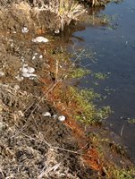
Orange ooze gives clues for those in the know.

If you walk your property with an eye to understanding how it works, knowing what orange ooze is and what it means is a worthy skill. Orange ooze forms where anaerobic waters seep from the ground. This can be a good and natural thing, as in the image.
Reduced iron (Fe(II)) is a source of energy for life, including iron-oxidizing bacteria. The oxidized iron gives orange ooze its distinctive color. Another distinctive feature of anaerobic waters is a surface sheen, reminiscent in appearance of an oil sheen, but brittle.
Anaerobic waters form for specific reasons.
Unfortunately, one reason is contamination. A classic source of Fe(II) laden waters are acidified drain waters associated with mining and industrial wastes. Other reasons are septic systems, waste water lagoons and land fill leachate. Fuel leaking from a transfer line is a classic source. Any substance that can be rapidly decomposed by microbial activity, even a benign dust control product like lignin sulfonate, can result in anaerobic groundwater if concentrated by runoff in a roadside ditch.
Anaerobic groundwater formation is usually natural. Examples are flows through wetland conditions (as in the image) and through pond bottoms. In natural cases, orange ooze relates to elevated microbial activity. This biological activity usually needs a temperature above 41 degrees F (5 decrees C) and an adequate food supply to support microbial respiration in excess of oxygen supplies.
Now look closely at the image. Notice the greenest vegetation is in the band of water with the anaerobic sheen, parallel, and below the orange ooze. That is because the seep water is warmer than the surface water it is flowing into, stimulating a difference in plant growth. The elevation of the orange ooze shows the anaerobic water is dropping into the stream. Not shown is that it is on only one side of the stream and only along a limited stretch. This gives important clues as to where to look for the source, in this case wetland conditions in the pasture adjoining the stream. The warmth of the seep indicates that the hydrology supporting wetland living conditions is not localized winter precipitation and snow melt, but has deeper, less seasonal, origins.


Sunday, February 05, 2006

Farm tile drainage progressing rapidly (II)

As mentioned here earlier, farm tile drainage is being linked to accelerated wetland loss in Minnesota. A meeting held Saturday, February 5, to discuss wetland loss drew a crowd of 300. One person testified that “99 - 100%” of the wetlands in his county were now gone. Details are reported in the St. Paul MN Pioneer Press article with the headline: “Get tough to protect wetlands, group says”. Reading the tone of the reporting, it confirms my earlier impresssion that the majority of the wetland loss is considered to be due to draining uplands adjacent to wetlands. My read (see pdf addressing MN wetland regs) is that this is normally a legal undertaking. Installing drain tile within a wetland would not be legal. This foreseeable cause of wetland loss, due to activities outside of wetlands, seems to have caught wetland advocates without a workable strategy.


Sunday, January 29, 2006

Farm tile drainage progressing rapidly

As told by Chris Niskanen over at the St. Paul MN Pioneer Press there is a tremendous amount of tile drainage going on in the north central USA: 100 million feet per year or about 19,000 miles by one estimate. Improved flexible drain tile is making this unprecedented rate of installation possible. The article mentions a number of areas of potential concern: loss of duck habitat and increased nitrate levels in surface water. Where no jurisdictional wetlands are being tiled, no permits are needed to perform this work. However the extent of the practice has caught the attention of folks and a community effort to address the impact of farm drainage on wetland habitat is being discussed.
Image source: South Dakota State University – Ag environmental issues page
Tech Tags:

Friday, December 30, 2005

Indicator of Reduction in Soils (IRIS)

The list of activities and structures that don't do so well in reduced conditions is pretty long: septic drain fields, crops and steel underground storage tanks come to mind. On the other hand, reduced conditions are a requirement for jurisdictional wetland designation and constructed wetlands. Beyond that, watching the playoff between various redox gradients in soil is just plain fun.

Pedology and Wetland Soils

B. J. Jenkinson and D. P. Franzmeier*

Dept. of Agronomy, Purdue Univ., Lilly Hall of Life Sciences, 915 W. State St., West Lafayette, IN 47907-2054

* Corresponding author (dfranzme@purdue.edu )

Soil drainage conditions are important to land use decisions. Traditionally, anaerobic conditions induced by poor drainage have been evaluated by observing soil color related to Fe and Mn oxides, using {alpha}, {alpha}-dipyridyl dye, measuring dissolved O2, and measuring EH. We believe that there is further need for a device that is scientifically sound and easy to use. Therefore, our goals were to develop and test a device that mimics natural soil processes, visually indicates soil reduction, and is robust. Our concept was to coat a rod or tube with a colored soil mineral that dissolves on reduction, insert the device into a soil, remove it after a few weeks or longer, and observe if some of the coating had been lost. If the coating was not dissolved, no reduction occurred, but if it was dissolved, reducing conditions must have prevailed. After trying several kinds of coatings and tubes, we chose ferrihydrite (FH) coating on polyvinyl chloride (PVC) pipe. We call the device an Indicator of Reduction in Soils (IRIS). As the study progressed we added semi-quantitative interpretations by measuring depleted areas using a digital camera and image analysis. We tested IRIS tubes in the lab and in soils in Indiana, Minnesota, and North Dakota, and concluded they performed as expected. Reduction rates increased between February and April and were related to increasing soil temperature, turnover (flux) of soil OC, and content (inventory) of OC. Reduction rates decreased after April, presumably because the nutrient supply for microbes decreased.


Abbreviations: Ac, area of FH coating in contact with the soil • Ad, area from which some FH had been depleted • D, percentage of Ac from which some FH had been depleted • DO, dissolved O2 concentration • FH, ferrihydrite • IRIS, indicator(s) of reduction in soils • OC, organic carbon • PVC, polyvinyl chloride • UDD, upper depth of FH depletion


Easy and straightforward. Kind of like the traditional sticking of the toothpick into the banana bread to see if it's done.

Note: I updated this article a few hours after posting the original. If you read the first version, my sympathies. What can I say. Its a gift.

Further Reading:
Redoximorphic Features Powerpoint presentation developed by: Michael Whited, USDA-NRCS - Wetland Science Institute August, 2000. (4.6 MB) (source page )

Technorati Tags:

Tuesday, December 27, 2005

In Praise of Richmond Bartlett

“We all should fall upon our knees and sing out praise for manganese.�
Richmond Bartlett (wikiquote)

I received the following from Paul Bloom earlier today.

Below is an announcement supplied by Don Ross of the University of Vermont. I truly enjoyed the times I got to sit and discuss life and science with Rich. He was as unique character, but more that he was a good scientist and a fine human being.

Paul Bloom

Richmond Bartlett died Tuesday, December 20 at the age of 78. His contributions to the field of soil chemistry were many and he will be missed. He would surely want everyone to remember the difference between soil and dirt, and the fact that manganese can explain everything (almost). There are plans for a memorial service on Saturday January 7th on the campus of the University of Vermont in Burlington, time and place to be announced.


Technorati Tags: