Showing posts with label information. Show all posts

Monday, March 05, 2007

GeoAgro soil data collector


I just got back from the 20th Annual Meeting of the NSCSS in San Antonio, TX. Ed DiPollina, TekConsultants, was one of the presenters, and I was very impressed with the potential for a product his company is bringing to market, the GeoAgro Soil Data Collector. Designed for field soil scientists like myself, the Soil Data Collector helps us log soil profile descriptions and geo-reference our field notations, map features & test pit locations in the field on a Tablet PC.

I saw many NSCSS soil scientists sign on as beta testers. Considering the varied applications that field soils data is applied to, this is surely going to be an interesting process.

Similar field data solutions are available to government soil scientists (Pedon PC software was presented to us by USDA-NRCS in San Antonio), but the GeoAgro Soil Data Collector is the first one geared to consulting field soil scientists, arguably a larger and faster growing market than represented by government soil scientists.

It struck me during Ed DiPollina's presentation that the GIS and GPS portion of these types of products is becoming more of a commodity, with the forms and data entry portion holding the interest of the San Antonio audience.

Unlike similar solutions geared to institutional needs, this product will be affordable for the small business to enter into. This is not always a given since GIS solutions vary wildly in price relative to the value provided. If you are already using a GIS product like ESRI's ArcView (ESRI is the world leader in GIS software), no problem, the Soil Data Collector has the ability to export and import different types of files, such as shape, drawing and spreadsheet formats, along with substantial GIS functionality. Don't already have a GIS solution? A simplified non-ESRI solution is being provided.

Speaking of ESRI, affordable alternatives to ESRI products are on the rise. If you are already a locked into being a customer of ESRI, or you are a status quo driven public institution, this will not matter to you. A growing number of us are not. We constitute a market that ESRI has pointedly chosen, through proprietary file formatting and opportunistic pricing, not to serve. I don't fault ESRI for choosing a captive market business model. Its a legit choice. Unfortunately for ESRI, and ultimately ESRI's customers, it is difficult model to adapt to changing market conditions. If the monopolistic aspects of ESRI have escaped you, consider. GIS solutions are simple, ubiquitous, data processing solutions for publicly available georeferenced data. The algorithms used to project the data into only 2 dimensions were constructed long ago by federal agencies using public funds. The math and the data are both freely available to everyone. ESRI doesn't add value to data in the classic meaning of value, it locks it into a proprietary format and holds it for ransom.

A captive market business model smothers the necessity to innovate. Over at competitor Manifold System GIS, several sub$1K solutions are optimized for multiple core CPUs and 64 bit processing. This has been available since August, 2006. ESRI has yet to announce when they intend to provide multi-core or 64 bit functionality, even at the >$120K level. Some generally similar observations about ESRI: (1) (2) (3)

ESRI's loosening grip on the lead and a general increase in GIS software choice and capability are helping to bring innovators like TekConsultants onto the playing field.


Technorati Tags:

Monday, March 27, 2006

Public Access to Public Data

In a development that has far reaching implications for public access to publicly funded geodata, the Guardian reported last Thursday that Tim Berners-Lee has made a speech to an Oxford University audience in which he challenged the British government to make Ordinance Survey mapping data available at no cost for Web use and

may get his wish later this year. Sir Tim Berners-Lee told an Oxford University audience last week getting "basic, raw data from Ordnance Survey" online would help build the "semantic web", which he defines as a web of data using standard formats so that relevant data can be found and processed by computers.

Berners-Lee said it may be reasonable for OS, the premier state-owned supplier of public sector information, to continue to charge for its high-resolution mapping. But even if licences were required, he added, OS should make its data open to manipulation. "I want to do something with the data, I want to be able to join it with all my other data," he said. "I want to be able to do Google Maps things to a ridiculous extent, and not limited in the way that Google Maps is."

The guest lecturer said he had discussed this with OS. "They are certainly thinking about this and studying what they can do. OS is in favour of doing the right thing for the country, as well as maintaining its existence, so I think there's a fair chance we'll find mutual agreement."


This relates to a similarly controversial subject in my State and anywhere else in the United States where individual datasets for current county coverage can cost the purchaser thousands of dollars and be encumbered with copyright restrictions and in proprietary MrSID or ESRI formats. As someone else said:
In the United States there seem to be two contradictory trends in public access to public data. On the one hand, more public data than ever before is being published on the Internet for free download. On the other hand, many public agencies ignore laws guaranteeing public access to public data, or they are providing the data in a form that renders it unusable by the public.

Roger Longhorn, Info-Dynamics Research Associates Ltd points out that
It is important to remember that, in the USA, free (no cost) access to geodata applies only to federally collected (or paid for) data. State and local government, holders of vast quantities of geodata, can (and some do) charge for access and/or exploitation of these important, typically large scale, geodata resources.

Local governments charge fees at levels that discourage innovation, throttle data dissemination, skew distribution and discourage data reuse. I don't mind paying a reasonable fee and I truly don't mind local governments recouping reasonable cost. Hundreds of dollars and in some cases, thousands of dollars, per data set is not reasonable. Consider that these same agencies and districts would have to provide this data at the cost of copying it to CD's if requested under their freedom of information requirements. The difference in charges is for timely delivery and the substantial benefits that derive from being a team player.

Yet it is unseemly for us in the United States to complain. Our nation's history supports the basic premise that "one of the reasons to have a government is to have good map data" available to the public. Post-9/11 security concerns have clouded the issue but (as analyzed in this pdf)have not changed the fundamentals.

Rapid developments in the UK and UE will encourage those in the USA working to make publicly funded data more freely available, and less encumbered with restrictive copyrights and proprietary formats. What goes around, comes around.

Complementing open geodata efforts is the open source geospatial technologies movement. The newly formed Open Source Geospatial Foundation (discussed here, here and here) will develop the standards needed for open source to advance. I hope both movements, open source and open data, do well. On both sides of the Atlantic.


Tech Tags:

Saturday, January 28, 2006

Glomalin, science, CO2 and climate change

Atmospheric CO2 concentration is expected to increase by 50% near the middle of this century. Indications are strong that rising CO2 effects higher soil organic carbon content in some cases. Glomalin, which accounts for 1/3 of soil carbon, is of particular interest because of its important role in binding soil aggregates and increasing nitrogen use efficiency. The Center for the Study of Carbon Dioxide and Global Change has updated their excellent summary about the CO2 - glomalin relationship. There is a great reference list to dive into.

Image source: USDA-ARS: Glomalin: A Manageable Soil Glue (pdf brochure)


Thursday, January 26, 2006

Product review - new vadose zone research tool moves to farm

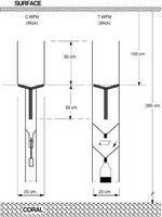
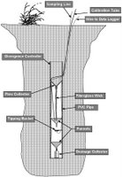
Irrigated farm fields lose water to deep percolation. This groundwater recharge, and what it contains, is difficult to research. This is because sampling tools designed to intercept saturated flow tend to miss unsaturated flow. And visa versa. New technology extracts deep soil moisture using a wick rather than the active suction or gravity.

The first wick samplers were passive capillary samplers (PCS). This approach has now evolved into the current water flux meter (WFM) designed recently by Batelle soil scientist Glendon Gee. Two offspring WFM designs are commercially available: the Gee passive capillary sampler drain gauge (Decagon Devices, Pullman WA) and the vadose zone water flux meter (Sledge Sales Consulting, Dayton OR). In a recent journal article, the Decagon device is referred to as a capacitance water flux meter (C-WFM) and the Sledge device is referred to as a tipping-bucket water flux meter (T-WFM). The T-WFM is close to Glendon Gee's designs published in journal articles. The C-WFM was developed by Decagon soil scientist Gaylon Campbell in collaboration with Glendon Gee.

The original PCS devices needed a pit, best dug with a backhoe. Fiberglass wick length and strand size were calibrated to site specific conditions to prevent oversampling of unsaturated conditions. Today's WFMs can be placed in an auger hole or hand-dug pit. WFM configurations use a standard size and length wick which works for most situations. A recent journal article has an example of an oversampling problem.

There are strong similarities and distinct differences between the two firms. Like Decagon, Sledge maintains strong ties with Glendon Gee. Like Decagon, many of the 200 devices Sledge has produced have been for agricultural research. Compared to Decagon, Sledge is more a hands on, farm service and farm chemical oriented consulting business. With Wayne Sledge, the T-WFM is his flagship product. With Decagon, the C-WFM is a sensible addition, part of an extensive and well supported line of soil and agricultural measurement instrumentation. It appears that Decagon and Sledge have produced a similar number of devices and they are clearly on parallel tracks of success in refining their individual product.

Both firms have supplied most of their instruments to agricultural researchers, farms and clients concerned with water use efficiency and nitrogen use eficiency such as golf courses. There has also been environmental project placements, most often associated with landfill and mine-tailing closure

Decagon has put considerable effort into refining unit capacity to record water flux, less into water sample handling. The larger base of the Sledge unit enhances water sample handling options. Decagon has a stepped design which accommodates hand auguring the deepest portion, shortening installation time. Decagon has an extensive list of complementary devices and highly capable technical support staff. The Sledge unit is substantially lower in price. Choice is good.

Of particular interest in Washington State is wastewater spray field management. As mentioned in a government report: "The Department of Ecology has identified 20 spray field situations where wastewater was [improperly] applied [and conditions] ... led to contamination of groundwater...". This report was discussed here previously.

I spoke with Don Nichols, with Washington Department of Ecology's Water Quality Program, Eastern Regional Office, Spokane, WA. Don has encouraged the installation of WFMs for gathering vadose zone water quality information. Don referred me to Cascade Earth Sciences and Soil Test Farm Consultants for more information.

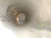
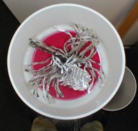
Dan Burgard, soil scientist with Cascade Earth Sciences (CES) in Spokane, WA has installed 7 Decagon C-WFMs in the Pasco, WA area, and 11 Sledge T-WFMs in southern California. CES modified the equipment to enhance sample collection capabilities. (See his photos below)

Dan Nelson, soil scientist with Soiltest Farm Consultants, Inc. in Moses Lake, WA has four Decagon C-WFMs installed in the Moses Lake, WA area. Both had nothing but good things to say about the potential uses of this type of data. Mass balance calculations will demonstrate if target water use efficiency and target nitrogen use efficiency is being achieved. Detailed daily data logs show exactly when percolation occurs. Percolation events observed to date are closely correlated with irrigation and precipitation events and even soil thawing events. As expected with the difference in weight between soil and the field capacity water portion, percolate nitrate and dissolved solids (salts) are several times higher than soil levels above the sample point. The devices are performing as intended.

One question I have is how many devices are needed to achieve statistical confidence in a mass balance calculation? Users independently tend toward sets of 3 units, with singles for spot comparison data. That is a sensible starting point but determining coefficient of variability on selected data would put the results into perspective.


None of the installations have been entirely glitch-free, mostly due to various data logger challenges or site specific soil related factors, such as coarse sands or depth limits. Users of the units are looking forward to continued refinements in data logger compatibility and would like to see costs come down and but give high marks for ease of installation and setup. This and available tech support make sampler units from Sledge and Decagon an attractive alternative to the do-it-yourself installations that predate this equipment.


References:
Brown, K.W., J.C. Thomas, and M.W. Holder. 1986. Development of a capillary wick unsaturated zone water sampler. Coop. Agreement CR812316-01-0. USEPA Environ. Monit. Syst. Lab., Las Vegas, NV.
Cary, J.W. 1968. An instrument for in situ measurements of soil moisture flow and suction. Soil Sci. Soc. Am. Proc. 32:3–5.
Gee, Glendon W., Zhang, Z. Fred, Ward, Andy L. 2003. A Modified Vadose Zone Fluxmeter with Solution Collection Capability Vadose Zone J 2003 2: 627-632 (highwire link) http://highwire.stanford.edu/
Knutson, J.H., and J.S. Selker. 1994. Unsaturated hydraulic conductivities of fiberglass wicks and designing capillary wick pore-water samplers. Soil Sci. Soc. Am. J. 58:721–729.
Selker
, J.S., C.K. Keller, J.T. McCord. 1999. Vadose Zone Processes, Lewis Publishers, ISBN 0-87371-953-0, GB1197.7.S46 1999 [1] [2]
van der Velde, M., Green, S. R., Gee, G. W., Vanclooster, M., Clothier, B. E. Evaluation of Drainage from Passive Suction and Nonsuction Flux Meters in a Volcanic Clay Soil under Tropical Conditions Vadose Zone J 2005 4: 1201-1209 (DOI: 10.2136/vzj2005.0011) (highwire link)


Monday, January 16, 2006

Tetany animal health issue and soil, hay links

Tetany is a complex disease in that no specific condition triggers it in all cases. Gauge tetany risk using soil and tissue analysis when growing or feeding hay comprised solely of cool-season grasses. A grass-legume mix does not have this risk.

Tetany is a disease affecting ruminants and is associated with feeding or grazing bluegrass, bromegrass, fescue, orchardgrass, ryegrass, timothy and wheatgrass. It is caused by low blood levels of calcium and/or magnesium. Classic risk conditions occur when the forage grass is growing quickly in the spring and nitrogen levels are high. Less well known is that tetany can be a problem when hay is grown on soils with excessive soil potassium. Manure and potassium hydroxide cleansers are two potential sources. Lactating animals are more susceptible to tetany, thus dairies are particularly alert to the concern and tend to avoid growing or feeding grass hay exclusively. Forage guides may not mention it as a concern. A forage tissue ratio of K/(Ca+Mg) of more than 2.2 indicates a high risk of tetany and the need to supplement feed with magnesium (Mg) (see also). If an animal goes down and tetany is suspected, a veterinarian should be contacted for immediate treatment. Often an animal will recover if it can be given an injection of magnesium sulfate (Epsom salts) early on.

Preventative Mg feed supplement and the ready supply of alfalfa tends to keep the incidence of tetany to a minimum. My thought is that tetany is additionally controlled by the close knit nature of farm communities. Caring neighbors and long memories tend to interact sufficiently that tetany symptoms don't take more than an animal or two, usually the weakest anyway, before it is figured out. Perhaps this explains why analytical laboratories in my region are generally unaware of tetany or the role of soil and tissue nutrient levels. My opinion is that cooperative extension publications in the Pacific Northwest can do better in this area. Tips for preventing animal loss due to tetany should be included in the fertility guides published to help folk interpret forage test results.

See also:
Spring Mineral Considerations by Jeff Heldt (link added 03MAR06)
Controlling Grass Tetany in Livestock, by Cooperative Extension, New Mexico State University, available in pdf format

Tech Tags: