Wednesday, March 29, 2006

Older than Dirt

Bill Gurstelle over at The Technology Underground Blog states that, having turned 50 years old today, he realizes that he is easily older than dirt. And does a fair job of proving it out, quoting John Adams on compost, posting a swell picture of compost (hmmmm. dirt.) and pointing out that compost produces fresh dirt in less time than it takes to live to be 50. I'm down with that. Happy birthday to you Bill.


Tech Tags:

Monday, March 27, 2006

Public Access to Public Data

In a development that has far reaching implications for public access to publicly funded geodata, the Guardian reported last Thursday that Tim Berners-Lee has made a speech to an Oxford University audience in which he challenged the British government to make Ordinance Survey mapping data available at no cost for Web use and

may get his wish later this year. Sir Tim Berners-Lee told an Oxford University audience last week getting "basic, raw data from Ordnance Survey" online would help build the "semantic web", which he defines as a web of data using standard formats so that relevant data can be found and processed by computers.

Berners-Lee said it may be reasonable for OS, the premier state-owned supplier of public sector information, to continue to charge for its high-resolution mapping. But even if licences were required, he added, OS should make its data open to manipulation. "I want to do something with the data, I want to be able to join it with all my other data," he said. "I want to be able to do Google Maps things to a ridiculous extent, and not limited in the way that Google Maps is."

The guest lecturer said he had discussed this with OS. "They are certainly thinking about this and studying what they can do. OS is in favour of doing the right thing for the country, as well as maintaining its existence, so I think there's a fair chance we'll find mutual agreement."


This relates to a similarly controversial subject in my State and anywhere else in the United States where individual datasets for current county coverage can cost the purchaser thousands of dollars and be encumbered with copyright restrictions and in proprietary MrSID or ESRI formats. As someone else said:
In the United States there seem to be two contradictory trends in public access to public data. On the one hand, more public data than ever before is being published on the Internet for free download. On the other hand, many public agencies ignore laws guaranteeing public access to public data, or they are providing the data in a form that renders it unusable by the public.

Roger Longhorn, Info-Dynamics Research Associates Ltd points out that
It is important to remember that, in the USA, free (no cost) access to geodata applies only to federally collected (or paid for) data. State and local government, holders of vast quantities of geodata, can (and some do) charge for access and/or exploitation of these important, typically large scale, geodata resources.

Local governments charge fees at levels that discourage innovation, throttle data dissemination, skew distribution and discourage data reuse. I don't mind paying a reasonable fee and I truly don't mind local governments recouping reasonable cost. Hundreds of dollars and in some cases, thousands of dollars, per data set is not reasonable. Consider that these same agencies and districts would have to provide this data at the cost of copying it to CD's if requested under their freedom of information requirements. The difference in charges is for timely delivery and the substantial benefits that derive from being a team player.

Yet it is unseemly for us in the United States to complain. Our nation's history supports the basic premise that "one of the reasons to have a government is to have good map data" available to the public. Post-9/11 security concerns have clouded the issue but (as analyzed in this pdf)have not changed the fundamentals.

Rapid developments in the UK and UE will encourage those in the USA working to make publicly funded data more freely available, and less encumbered with restrictive copyrights and proprietary formats. What goes around, comes around.

Complementing open geodata efforts is the open source geospatial technologies movement. The newly formed Open Source Geospatial Foundation (discussed here, here and here) will develop the standards needed for open source to advance. I hope both movements, open source and open data, do well. On both sides of the Atlantic.


Tech Tags:

Saturday, March 25, 2006

Missoula Soil Science Consultant Speaks

Tell someone you are a soil scientist and it invariably requires an explanation of what you do. It's interesting that few of us do the same things and the telling of it reveals much about the person as well as the community they serve. For that reason I like to collect other folks' descriptions of their work. Certainly the telling of Barry Dutton's life work stands among my favorites because he built his business from scratch in a particularly cost-conscious region. He did it largely without the benefit of the 2 main drivers of regional soil consulting booms: booming suburban sprawl and booming energy prices driving increased well drilling and surface mining for coal and oil shale. I've heard several iterations of Barry's telling over the years and look forward to future installments.

Barry Dutton consults out of Missoula, Montana for PBS&J which purchased his company last year. Barry addressed the June 14, 2004 National Cooperative Soil Survey Western Regional Conference in Jackson, Wyoming (pdf source):

I was asked to review what private soil scientists are up to these days and will use my own company to illustrate. I started Land and Water Consulting Inc. 25 years ago and now have 50 employees and five offices. Our staff includes soil scientists, hydrologists, botanists, wetland scientists, biologists, water rights specialists, engineers, surveyors, GIS specialists, technicians and support staff. Our wetland projects this year include wetland delineation on over 10,000 acres. We will restore over 60 wetlands impacted by ski area and golf course development. We will design several dozen wetland mitigation projects and will monitor over 100 wetland projects constructed as mitigation for highway project impacts.

Our vegetation projects this year include several thousand acres of vegetation mapping for EIS studies, vegetation management plans for ski areas, and vegetation TES inventories for project sites. We will also conduct weed and riparian area inventories on private, state, and federal lands.

Our streambank and shoreline projects include restoration along hundred of miles of streams and lakes. We are working on removing a 100 year old dam on a large river within the largest superfund site in the country. This work includes channel design, wetland rehabilitation and riparian area enhancement. We will also conduct watershed analyses and implement TMDLs (Total Maximum Daily Loads) for dozens of streams.

I do a lot of expert witness work and soil survey often has a role in the cases. My oldest case has been going on for over 30 years and the focus is the definition of Peat. The 1911 Soil Survey got it right in describing the site as “high organic content silt loam.” However, the 1959 soil survey called the site peat. The owner sold the “peat” and has been arguing over the definition of peat ever since with the peat miner who purchased it. In another expert witness case, a friendly NRCS soil scientist tried to do a county planner and a developer a favor and produce a wetland map. Unfortunately this person had insufficient training in wetland delineation. The developer filled up to the wetland line and built a parking area before the ---- hit the fan. He spent $250,000 on lawyers, experts, fines and restoration activities to correct his mistakes and is now considering sending NRCS the bill. I am also involved each year in a half-dozen wet basement lawsuits and in almost every case there is a soil survey covering the site that predicted the problem if anyone had known or taken the time to look.

We are also involved in numerous reclamation projects for mine sites, pipelines and other projects. If you want to evaluate soil survey accuracy there is nothing like a 300 milelong pipeline trench across the landscape.

Likely because a longer litany wouldn't add any value, Barry didn't mention several other areas: his extensive work with water use efficiency for irrigation districts, his work instructing health district personnel on soil features relevant to septic systems and his work mapping soils but using project specific approaches that describing would only have distracted NCSS audience from his core message:

The decline of the soil survey program is leading the decline of the soil survey profession.

This is a powerful statement to lay on NCSS, the keepers of the national soil survey program. I plan on discussing it further.

Barry Dutton's message is also at the core of the brand of concern for soil science survival that I was dismissive of at the end of my previous post, a position based on observing the ever increasing demand for consulting soil scientists. Speak with Barry, as I did this afternoon, and you will find his concern is not waning despite his considerable business success and despite the high demand for his individual services. I am reevaluating my position and will present it in a future post. Certainly we soil scientists have the work but without academe, without soil survey sufficient to maintain our critical mass, won't what we do continue to be parceled out among the other disciplines? Any comments on this issue would be most appreciated.


Sunday, March 12, 2006

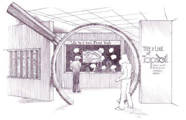
Smithsonian soil exhibit

Soils:Worlds Underfoot

From TroutGrrrl @ Science and Sarcasm:

The Smithsonian Institution, the Soil Science Society of America (SSSA), and others are planning a 5,000 square foot soil exhibit at the National Museum of Natural History in Washington, D.C. The projected opening for the “Soils:Worlds Underfoot,” exhibit, is 2008. The exhibit will occupy one entire hall of the museum and will be displayed for 1.5 years. It will feature state soil monoliths and interactive soil displays. Each of the 50 states and three U.S. territories will donate a monolith of their state soil for the display. A separate mobile exhibit will travel to hundreds of museums, schools, and libraries with soil education kits, web-based activities, curriculum, and career information.

The exhibit is expected to require 2+ years for the Smithsonian to design, build and install. Sponsored by the SSSA, the final decision about exhibit building, design, and content rests with the host: Smithsonian's National Museum of Natural History. The total cost is projected to be $4 million.

The exhibit will emphasize the living, biological nature of soils, the variation in soils from one region or locality to another, the dynamic nature of soil, the role soil plays in linking the earth's air, land and water resources, and the importance of taking care of our non-renewable soil resources.

This exhibit is welcomed with enthusiasm by soil scientists. It would be at any time, but now, when soil science is at the cross roads and with soil scientists keyed up about the profession, it is even more so.

Many soil scientists are asking if the profession can survive another generation. Soil science departments continue to close up shop, as they have been for 20 years. Soil science is being dismembered and parts allocated to engineering or agricultural disciplines. Retiring soil scientists in academe are not being replaced. USDA-NRCS soil scientist hiring is essentially frozen despite the fact that NRCS does not have the manpower to fulfill its soil mapping commitments. Without soil science graduates, and without jobs to attract them, my profession appears doomed. SSSA membership growth has leveled off, and reversed in 2005. SSSA Journal publishing revenues are under assault by the growing movement toward open access, depriving SSSA of revenues needed to combat the trend.

It may surprise some that I believe our profession is very healthy and is experiencing a most welcome transition. Soil scientists working for the federal government, agriculture or academe may be looking at a shrinking pool, but try to find a consulting soil scientist outside of these areas that is not working 50 and 60 and more hours a week.

Look at the fundamental need for the science. Recent discoveries about microbial diversity, glomalin and amazonian dark earth have occurred at a time when carbon sequestration (pdf), atmospheric CO2 fertilization effects and climate change have reminded folks that the complex role of soils is too important for reliance on second-hand information, simplistic models and large scale county soil map data. We need the soil scientists themselves, not just their research papers and their maps.

Open-access (OA) to published scientific articles may threaten our scientific institutions, but is healthy for the sciences and the individual scientists. OA opens up participation to a much larger scientific community, gaining more dynamic interaction and collegiality than it loses in the area of peer-review. Researchers are attracted to publish open access because OA papers are cited more than restricted access papers. Open access to research data will do more to prevent the recent rash of scientific misconduct than peer review alone can accomplish and at essentially no cost. Replacing peer-review with review-by-many looks increasingly workable. Supporters note that Watson and Crick's paper on the structure of DNA was published without the benefit peer-review.

The soil science licensing phenomenon continues to grow within the United States. The movement is now well established at a state level. Growth is mostly because of a pattern of septic system failure due to poorly understood soil dynamics. The growth of soil science licensing is in step with insurance premium growth for Health Districts to cover their septic system failures. Regions with the most failure have the most enthusiasm for licensing.

Whereas membership in the SSSA has peaked for now, membership growth in the National Society of Consulting Soil Scientists is growing steadily. Job offers for soil scientist positions with private sector environmental consulting firms and health districts now surpass job opportunities in agriculture, academe or the federal government. This indicates a healthy recognition of the role of soil science in dealing with all sustainable land use issues, not just those involving agriculture, range and forestry.

This is a time of great change for the profession, and great opportunity to advance the science.

Tech Tags: